Búsqueda por categoría
Búsqueda por categoría
Búsqueda por marca
Código: AD00012
Fabricante: Avidyne

Mercados: Aire Seguridad
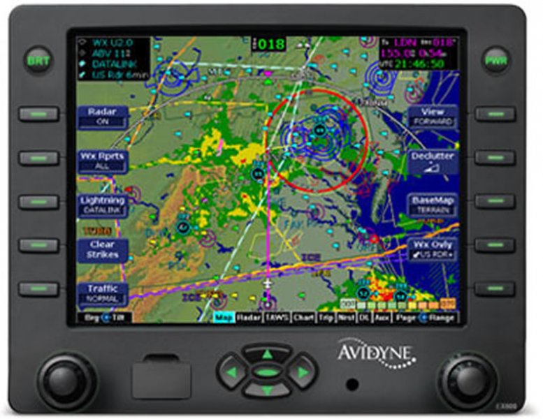
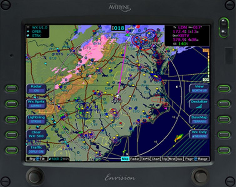
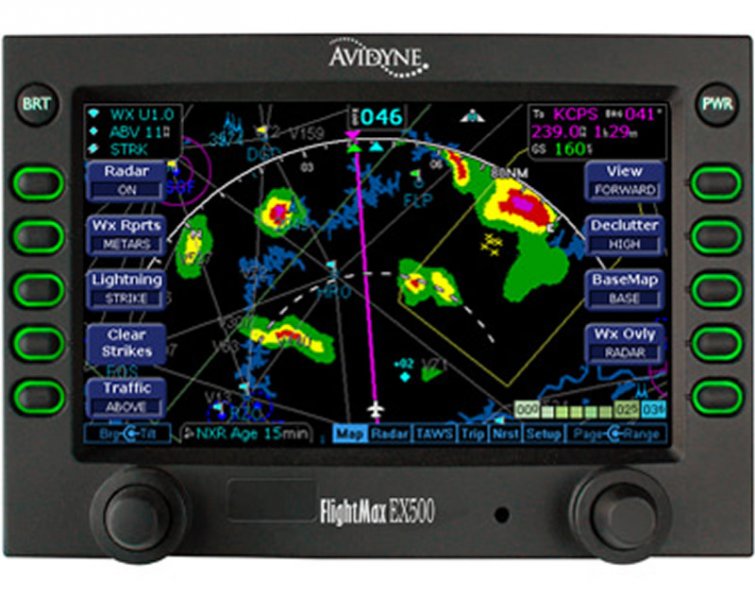
Avidyne?s EX600 delivers easy-to-use, datalink-ready multifunction display capability for general aviation airplanes & helicopters. Topics covered are: Map Centric Operation Map Panning and QuickPan Making your Radar better Trip page NRST page For best results, you may view the video in full screen by clicking the icon next to the volume control. The Avidyne Advantage Avidyne is committed to improving situational awareness and safety for general aviation pilots by focusing on developing products that are easier to use. Now, with our new EX600 Multi-Function Display (MFD), Avidyne offers the most feature-rich, pilot-friendly and easiest-to-use multifunction display available. The EX600?s user interface dramatically improves your ability to access and display critical flight data. This design philosophy keeps operation simple and consistent by allowing you to select and display what you need on a single easy-to interpret integrated moving map. As a radar display replacement, the EX600 provides easy access to radar modes, tilt control, and bearing adjust. With the EX600?s ?map-centric? operation and our new Map Panning feature, you can display a moving map of your flight plan and view datalink weather all along your route of flight. And view on-board Wx Radar. And special-use airspace. And traffic. And terrain. And color lightning. All without ever leaving the map page. It?s the only MFD available that provides the complete picture. And it?s the easiest to use. The Best MFD Available The EX600 keeps you connected with the complete weather picture, allowing you to view datalink graphical weather information that is seamlessly integrated with your flight plan moving map, lightning, traffic, and terrain display. Bigger, Brighter Display The EX600 features an all-new, high-resolution, sunlightreadable LED-backlit color liquid-crystal display that provides the brightest, most versatile big-screen display available. With over 40% more pixels than our previous-generation MFD, and an incredibly wide viewing angle, the EX600 provides the look and feel of big-screen MFDs. CMax Electronic Approach Charts All EX600s include CMax, providing a world-wide library of geo-referenced approach charts and airport diagrams that help you manage and access critical flight information and reduce the amount of paper required on board your aircraft. Utilizing Jeppesen?s trusted JeppView? Electronic Airway Manual, CMax makes accessing an approach or viewing an airport diagram a breeze. At startup, your departure airport chart is automatically loaded for ease of orientation, especially at unfamiliar fields. Your destination airport diagram and the list of available approaches are automatically loaded at the time your flight plan is entered. Charts can also be loaded for nearby airports along your route from the Trip Page using the EX600?s Auto-Fill. Radar, Datalink Weather & More Weather is a critical factor in the successful completion of any flight and Avidyne leads the industry in weather avoidance-capable multifunction displays. In addition to interfacing with 19 different on-board weather radar systems, the EX600 also displays color lightning and both broadcast and two-way satellite datalink weather. Broadcast Satellite Datalink Weather for CONUS The EX600 displays Broadcast Datalink weather giving pilots comprehensive, graphical information about weather conditions all across the Continental United States (CONUS). The EX600 displays NEXRAD radar mosaic, Hail Warnings, AIRMETs, SIGMETs, graphical and textual METARs, TAFs, Temperatures and Winds Aloft, TFRs, and datalinked Lightning. World-Wide Two-Way Satellite Datalink Weather Internationally, the MLX770 Satellite Datalink Transceiver delivers worldwide satellite-based datalink weather and two-way text messaging for EX600 owners flying anywhere in the world. International weather products include worldwide METARs, TAFs, SAT IR, Lightning, and regionalized NEXRAD radar imagery. CMax Airport Diagrams CMax airport diagrams include 6,004 worldwide locations, 5,695 of which are geo- referenced charts, meaning the EX600 MFD can overlay the flight plan and aircraft ownship symbol, making it possible to view the aircraft position directly on runways, taxiways, and ramps. Panning keys allow details of the chart to be shown. Informative Trip Page From the Trip Page, you have easy access to vital information, including graphical METARs for all reporting airports and one-button access to CMax approach charts for any airport along your route. Decoded METARs, Textual TAFs, and Winds and Temperatures Aloft can also be viewed at the push of a button. Unique NRST to Destination Page In addition to ?Nearest to Present Position,? the EX600 also provides Avidyne?s unique ?Nearest to Destination? Page which shows graphical and decoded METARs at the destination and surrounding airports, making it easy to monitor weather ahead and to select an alternate when needed. Map Panning & QuickPan With the EX600, Avidyne has added an easy-to-use panning function that allows you to scroll to virtually any point on the map to view weather, airspace, and other points of interest. Dedicated panning keys make it easy to view any area on the map, especially helpful for viewing weather at your destination. The four directional keys provide precise control, and the center key enables Avidyne?s exclusive QuickPan feature, which toggles the display between the panned position and your present position. While panning, the map can be zoomed in or out so you can easily see the close-in details or see the whole picture. Two-Way Text Messaging When interfaced with the MLX770, you not only get worldwide weather, but you also have the ability to send and receive text messages or emails while flying, allowing you to communicate with someone on the ground via an e-mail connection or compatible SMS-capable mobile telephone. Wx Radar over Map In addition to a dedicated radar page like other MFDs offer, the EX600 is the only MFD that can overlay your on-board Wx Radar right on your base map, along with Flight Plan, Terrain, Traffic, SUAs and datalinked weather data such as graphical METARs, SIGMETs, and AIRMETs. Color Tactical Lightning The EX600 can also interface with the Avidyne TWX670 to display real-time color lightning overlaid right on the moving map. On-board lightning provides a tactical complement to the strategic benefits of satellite-based datalink weather, and the addition of color provides more meaningful display of critical weather data. Replaces Your Old Radar Indicator The EX600 can also interface with the Avidyne TWX670 to display real-time color lightning overlaid right on the moving map. On-board lightning provides a tactical complement to the strategic benefits of satellite-based datalink weather, and the addition of color provides more meaningful display of critical weather data. Replaces Your Old Radar Indicator Helicopter operators will appreciate the versatility of the EX600?s detailed moving maps and the ability to display Traffic, TAWS, Charts, and Datalink Weather. (EGPWS/TAWS shown) World-Wide Datalink Weather International customers will appreciate the EX600?s ability to display worldwide satellite-based datalink weather and two-way text messaging when coupled with the Avidyne MLX770 Satellite Datalink Transceiver. (European Sat IR shown) Easy to Update. Easy to upgrade. NAV and Chart databases are easily updated through the USB port right on the front bezel. (European VFR charts shown) For existing EX500 customers, the EX600 is a pin-for-pin replacement that provides a larger display and adds our unique Map Panning capability.
AD00013
AD00014