Búsqueda por categoría
Búsqueda por categoría
Búsqueda por marca
Código: GA00003
Fabricante: Garmin

Mercados: Aire Seguridad
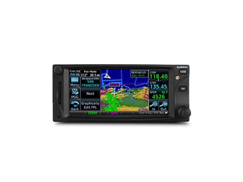
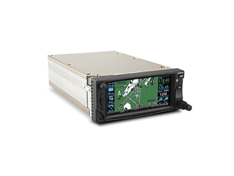
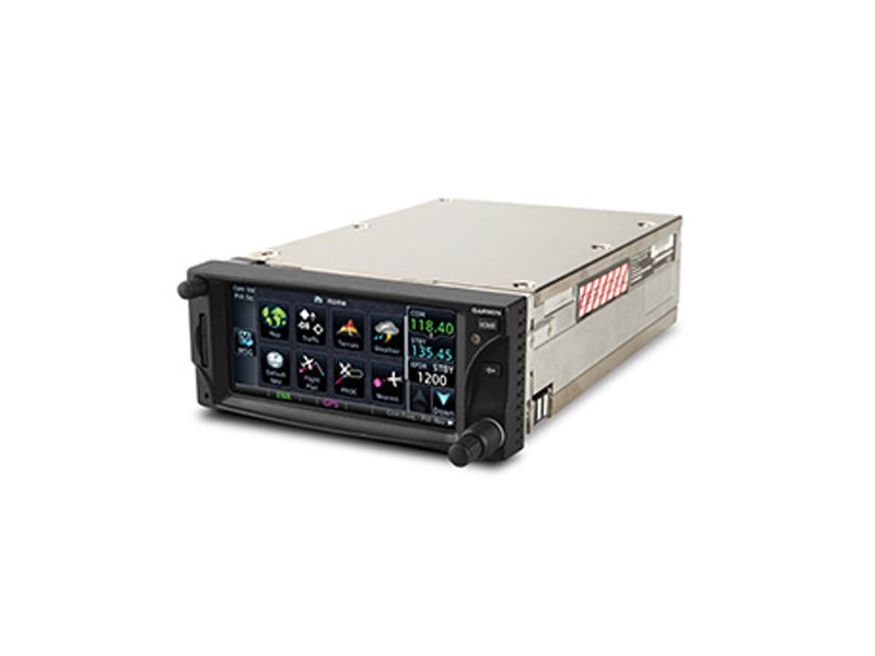
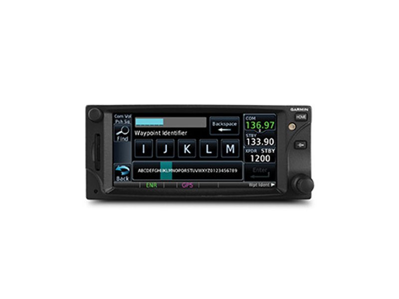
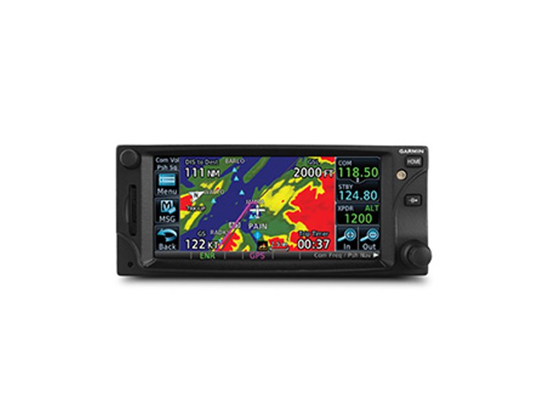
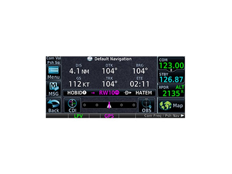
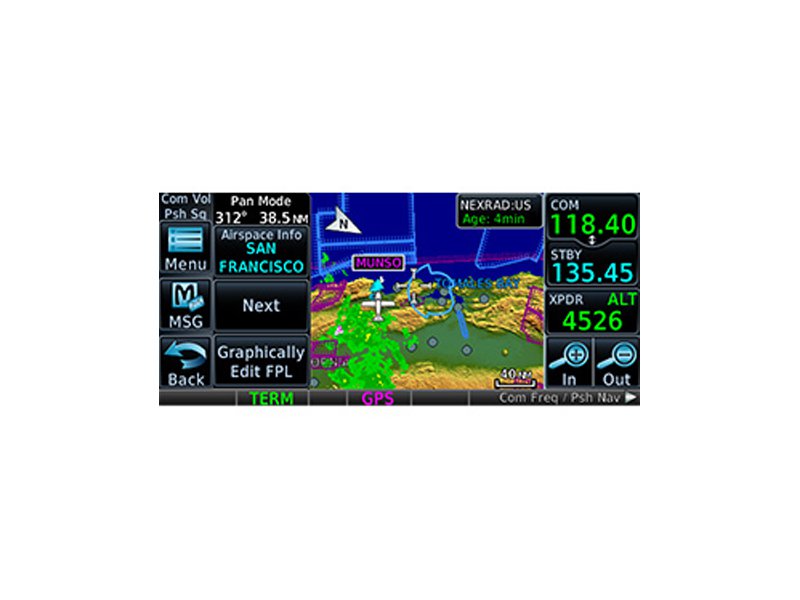
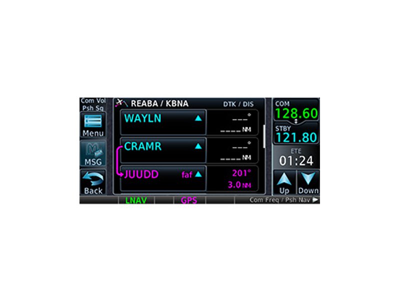
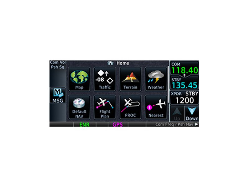
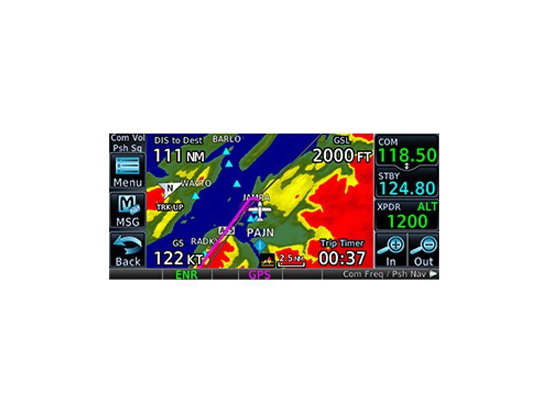
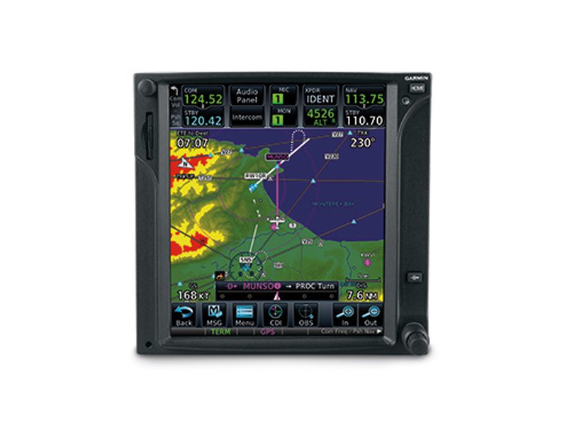
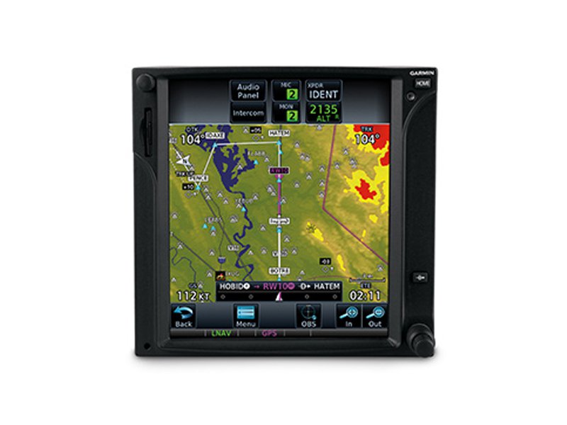
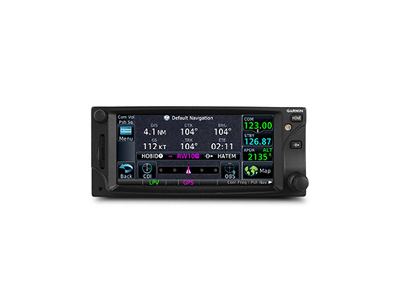
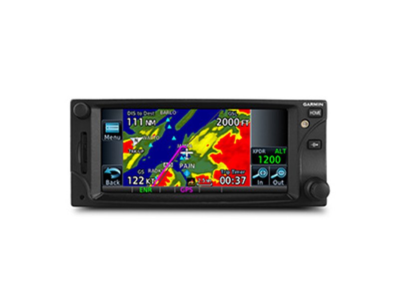
Do It All with this Space-saving Package Este producto requiere de items adicionales para su instalaci?n. Por consultas, escr?banos a info@redimec.com.ar Touchscreen GPS/Nav/Comm backed by decades of proven technology Fly WAAS LPV approaches down to 200 foot minimums Displays traffic, weather, terrain and more Interfaces with popular avionics using industry standard protocols Keep in sync with your iPad? and those on the ground with Connext GTN 650 GTN 650 is a fully integrated solution in a small package. It combines GPS, COM and NAV functions with powerful multifunction display capabilities such as high-resolution terrain mapping, graphical flight planning, multiple weather options, connectivity, traffic display and much more. GTN 650 Touch and Go With GTN 650?s touchscreen interface, you?re rarely more than 2 taps away from the system?s primary functions. Enter waypoint data on the 4.9-inch high-resolution TFT display and swipe your finger across it to pan the map screen. There are multiple ways to reach information and lots of shortcuts built right in. The data displayed can easily be customized to instantly reach any page in the system right from the moving map or navigation pages. So it?s easy to fly with the information that?s most important to you while flying. Built-in gripping points on the bezel and lower edge of the display help you stabilize your fingers while using the touchscreen in-flight. Not keen on touchscreen data entry? GTN 650 also has traditional concentric knobs. And, with a GNS 430W/530W, your active flight plan automatically crossfills from the GTN to the GNS. You can also manually crossfill waypoints. Navigate Easily It?s easier than ever to help ensure everything is in check, even before leaving the ground. The handy customizable checklist can be used to help ensure everything is ready to go from pre-flight to run-up to emergencies. It all begins with a simple and quick flight plan entry using FastFind which automatically begins searching for the nearest identifier just as soon as you start typing ? so in most situations a press or two reveals just what you were thinking. Edit your entire route on the map screen and easily enter new waypoints or modify existing ones. The system even lets you load Victor and jet airways. Grab any leg of your flight plan route and move it to accommodate a deviation or ATC amendment to your flight plan with the "rubber band" feature. Enter your most recently visited or nearest airports as waypoints and ?Direct To? destinations. You now have more landing options in IFR conditions. The SBAS/WAAS-certified, 15-channel GPS receiver generates 5 position updates per second, letting you fly GPS-guided LPV glidepath instrument approaches down to as low as 200 feet. The system includes a complete package of VHF navigation capabilities, with a 200-channel VOR/ILS with localizer and glideslope. GTN will preload NAV frequencies for you to manually switch to and can auto select the VHF NAV source for ILS approaches when you load procedures. When a VOR is selected, it displays the radial and distance to the VOR. In addition, precise course deviation and roll steering outputs can be coupled to select autopilots so that IFR flight procedures may be flown automatically. This includes all ARINC 424 leg types, except RF legs. For example, when coupled with a G500/G600 flight display, the aircraft can fly fully coupled missed approaches, including heading legs. Communication Is a Breeze A fully certified, 2,280-channel VHF communications transceiver provides a standard 10 W (or optional 16 W) of power output. The system is pilot-selectable to both 25 kHz and 8.33 kHz channel spacing. Set your standby COM frequency simply by touching the onscreen number pad ? it even completes the leading '1' and trailing '0' to help save time. Another touch of the screen flip-flops your active and standby frequencies. And you'll have added confidence knowing you're talking to the right controller every time with the automatic display of the station?s identifier right below the frequency, for example KIXD ASOS or CHICAGO ACC. Access recent and favorite user frequencies easily. For added safety, holding down the volume knob will automatically dial in the emergency frequency. The GTN also automatically decodes a station?s Morse code to provide a positive identification ? no aural decoding required. See More Than Ever Before Packed full of multifunction display capabilities, GTN 650 brings enhanced situational awareness to your cockpit. High-resolution terrain mapping ? including topography features, cities, airports, terminal areas, SUAs and optional Class A and B TAWS alerting ? you'll safely find your way around sectional-like airspace depiction, with convenient altitude limits right on the moving map. Smart Airspace? automatically highlights airspace close to your current altitude and de-emphasizes airspace away from the current altitude. On the ground, built-in Garmin SafeTaxi? airport diagrams show you geo-referenced runways, taxiways, FBOs and hangars available in either the U.S., Europe or Canada. Add Traffic and Weather The dual-link GDL? 88 allows GTN 650 to display up to 60 ADS-B traffic targets. TargetTrend? relative motion technology gives you a faster, more intuitive way to judge the direction and closure rate of intruding targets in relation to your aircraft?s position. And unique SURF technology supports the display of ADS-B-equipped surface targets on Garmin SafeTaxi? airport diagrams ? including taxiing aircraft and ground vehicles. For helicopter use, our exclusive On Scene traffic mode helps pilots prevent continued traffic alerting when they?re aware of other traffic in the vicinity. GDL 88 can also receive the FAA?s subscription-free FIS-B weather broadcasts that include graphical NEXRAD radar information, as well as NOTAMs, METARs and TAFs. GTN provides GDL 88 with the WAAS position source required for ADS-B, so a WAAS version of GDL 88 is not required. Add a Garmin Traffic System to compliment GDL 88 for the best possible traffic coverage. Add a GDL? 69/69A datalink receiver for XM WX Satellite Weather and SiriusXM Satellite Radio (subscriptions required). An optional GSR 56 provides World Wide Weather data almost anywhere on the globe, as well as the ability to make and receive phone calls and send and receive texts messages while in the air. Use GTN 650 with a Garmin Traffic System to help pinpoint other aircraft in your vicinity. And because it can control a GTX? 33 remote transponder, a GTN 650 installation saves you valuable panel space. Cockpit Connectivity Let our Connext family of products keep your flight plans in sync and stream weather, traffic, GPS, and attitude information to Garmin Pilot? on your iPad or select Android device by simply installing a Flight Stream 210. Use the flight plan already created and filed from Garmin Pilot to easily sync to your avionics upon hopping in the cockpit. And once airborne, it?s easier than ever to keep in sync with an ATC amendment ? with only a button press or two a new route updated on either the GTN or Garmin Pilot without cumbersome re-entry. You?ll also be streaming all of the weather, traffic, GPS and attitude information that your avionics is already providing which makes it easy to cut down on the cockpit clutter of other portable wireless device(s). Fly with Helicopter-specific Enhancements The GTN 650 is available with a number of optional enhancements to help meet the unique demands of helicopter missions. It?s been designed to meet the stringent helicopter vibration and temperature testing standards needed for environmental qualification. It also features a helicopter-specific obstacle database that adds nearly 30,000 low-altitude obstacles, as well as a navigation database with heliports and high-resolution terrain database. Remaining aware of where the wires are has never been easier than with Garmin WireAware?, wire-strike avoidance technology. WireAware graphically overlays the most comprehensive powerline information right on the moving map page for the U.S., as well as in some locations in both Canada and Mexico. In addition to its comprehensive coverage, using WireAware adds Hazardous Obstacle Transmission lines that span rivers and canyons and the like, which are particularly dangerous for aircraft. Nobody depicts powerline information quite like the GTN, each segment of the wire can be touched to instantly reveal both MSL and AGL ? and they?re also included in the obstacle alerting so they?ll shade either yellow or red given your distance to the lines. For the ultimate safety solution pair optional HTAWS alerting to provide 5-color shading and audible alerting to show nearby terrain, obstacles and wires in proximity to your helicopter as well as voice callouts when descending below 500 feet. And when you?re in the know of potential hazards, you can use our reduced protection and inhibit modes to help keep alerts to a minimum. When paired with a GRA 55, the GTN can be used to display the altitude and adds HTAWS alerting down to 50 feet.The GTN 650 is also optionally compatible with Night Vision Imaging Systems (NVIS) for use with a wide range of optics. GTN Trainer for iPadStay Up-to-date GTN 650 has a front-loading SD? card reader, making database updates easy. Keeping all of your GTN databases in sync has never been easier ? simply update 1 GTN and the other downloads the databases automatically, saving valuable time during the update process. Further, database preloading allows pilots to load the next release cycle in advance and activate upon the effective date, making it more convenient to fly with the latest information. PilotPak? database bundles are available for single aircraft. Visit flyGarmin.com to learn more. GTN 650 is now available for purchase from an authorized Garmin dealer. See it in action at an upcoming seminar or in person at a demo dealer location, or with our free downloadable PC Trainer or iPad app. *GPS receiver has a nominal operating velocity range of 0 ? 800 kts (411 m/s). iPad? is a trademark of Apple Inc., registered in the U.S. and other countries. Android? is a trademark of Google Inc. * Menu-driven interface on color LCD touchscreen display * Shows moving map, airways and approaches * GPS TSO?d to C146c, authorized for Class 1, 2 and 3 (LPV) * GPS WAAS-certified to Gamma-3 approach capability * WAAS-corrected GPS signal accuracy to 1 M RMS * Available built-in GPS/ILS/VOR/LOC and glideslope capabilities * Graphical flight planning (including airway navigation) * VHF COM transceiver: 8.33 or 25 kHz channel spacing * Com transmit power: 10 W standard, 16 W optional * Optional lightning, weather, traffic and TAWS-A and B terrain alerting * Integrated control/display for remote transponder * Flight control system interface for select autopilots * Optional SiriusXM Satellite Weather and Radio * SafeTaxi? airport diagrams * Award-winning product support and 2-year warranty
GA00001
GA00002
GA00004
GA00005

GA00031
GA00032
GA00039

GA00040

GA00041